LDMA - Loud Mine, Ga., Site
Loud Mine is the Lost Dutchman's Mining Association's, LDMA , Georgia site and is situated about 5 miles west of Cleveland, in the heart of the Georgia Gold belt. Loud Mine is one of the sites of a yearly GPAA outing. the Outing is usually held in the spring or fall. Check the main Gold Prospectors Association of America website for dates, associated costs, and further details on the LDMA.Plenty of areas for camping and RV's. With a clubhouse and bathhouse on site one doesn't rough it here.
Our Chapter was there in October 2016,
and many member have been there at other times over
the years. Gene and Val attended a GPAA Outing
in 2011, Mark was there in 2009 when Loud Mine Flooded
a bit, and Bob went to a GPAA Outing in 2007.
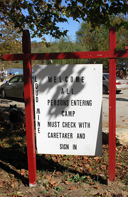
Loud Mine's welcome sign
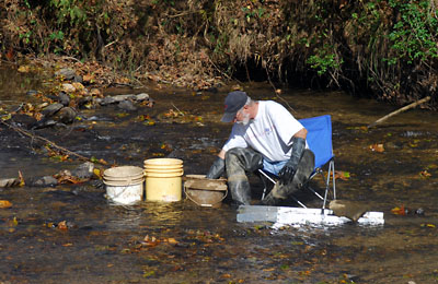
Working some paydirt in the creek.
Loud Mine is one of the few places one can find a bit of wire gold, fines, and small nuggets. Once in a while an Indian artifact might be found such as a bit of broken pottery or an arrowhead.
When visiting do not hesitate to head over to Dahlonega and visit the Gold Museum there. Dahlonega was one of the sites for the U.S. Mint from 1838 - 1861. Gold Coins from this mint will carry the "D" mint mark.
A bit of history of the area from the 1896 book;
"A Preliminary Report on a Part of the Gold Deposits of Georgia" By William Smith Yeates, Samuel Washington McCallie, Francis Plaisted King.
The Loud Mine, White County, GA. - The Loud Mine includes lots 39, 40, and 41, 1st District, White County. They lie in a North and South Range, Lot 39, being at the North; and each is said to contain 250 acres. It may be located generally as fourteen miles northeast of Dahlonega, or five miles west of Cleveland, the county-seat of White.
The geological formation is mica-schist and gneiss, with transitions onto, or dikes of hornblende-gniess. These strike usually about 45 degrees east, dipping from 30 degrees to 60 degrees to the southwest, rarely vertical or inclines to the northwest. The country is of an undulating character, hills seldom rising above the intervening valleys.
The auriferous material of this property may be classified as placers, saprolite and quartz veins. The placer area is quite extensive. They are characterized, by a maximum twenty foot �topping�, and from one to four feet of gravel. Coarse Gold and nuggets(1) prevail in the gravel. The Gravel rests on the slate or bedrock. The material above the gravel, or the �topping� composed, at it is, of the material washing from the hills, contains, in some places, quite a little gold, while at others, it is barren.
The hills have saprolite to some depth. This rotten rock, or saprolite, is the thoroughly decomposed and untransported mica-schists ans gniess. Such decomposition may extend to some depth as probably does on this property. Permeating this saproiite, are bands or stingers of quartz, conforming to the trend of the mica-shcists and gniesses, which are most frequently auriferous. The Hydraulicking of the hills rich in such quartz , on account of the easy concentration of the gold by amalgamation in sluices, is found exceedingly profitable, at several of the mines in this county, notably the Hamby Mountain and St. George, in the Nacoochee district.
Several quartz veins have been located but not tested. These all conform, in strike and dip, to the county-rock. The only-vein, which has been worked in the loud mine, runs diagonally through lot 39. This is the vein from witch the magnificent specimens of crystallized and wire gold, exhibited in this country and abroad, were taken. It was accidently discovered by Mr. Courtney of Cleveland, GA., while scrapping the underlying slate of placer. At the point of discovery (the northeast corner of lot 39), a shaft was sank immeadiatly; and for the first ten feet, the richness of the quartz in free gold is said to be astounding. The vein, a ribbon at the start, and a little over an inch in width, during it�s rich decent of ten feet, increased to a maximum width of two feet, and varied, back and forth, in thickness, to the depth of the shaft. At a depth of sixty feet, work was stopped, on account of their inability to cope with the water. From the depth of ten feet to the base of the shaft, gold was almost totally absent. A definite lateral tracing of this vein has never been undertaken. An out cropping of a quartz vein, however, two feet in width, occurs several thousand feet south west of the shaft, and may be traced back roughly to the shaft. Whether there are two distinct veins along this lead, or they are one and the same, cannot be conclusively asserted.
A small branch runs through the bottom, in which this vein is located. Good drainage will be necessary, before work, even in the placer, can be carried on. Although, at the shaft, the level is sixty feet above that of the Tessantee River, which flows along the eastern side of these lots, the topography is such that artificial drainage will be required. This may be accomplished, by running a drain to the Tessantee River(2), or, what would be more advantageous in several respects, by the use of hydraulic elevators. The placer itself is worthy of this outlay, and the vein certainly should not be ignored on account of it�s sudden barrenness. Gold veins are rarely uniformly rich; but, on the other hand, they hold the gold in pockets, shoots, or chimneys. Tapping a vein at only one point, by a small shaft without levels, cannot be considered a fair test. It may be possible, but it should not be considered probable, that a gold vein, which undoubtedly has been so material, in making the surrounding placer (worked of only about an acre) rich in nuggets and coarse gold has yielded, already, all its wealth.
Only a few years ago seven pounds of gold was removed from one spot, close to the shaft. It is in the neighborhood of the shaft, also, that many of the large nuggets, which have marked this property, have been found. While some of the gold obtained here, is smooth and water-worn, many of the specimens are very rough.
Very little prospecting for the location of veins has been undertaken. In fact, work on this property has been confined almost entirely to the placers, and these have been worked in the most primitive way. A ditch, twenty-one miles long, supplies the mines with water for hydraulicking and washing.
As well as can be determined, the placers alone offer legitimate fields for fair profits; and equal if not richer returns, may be expected from the saprolite areas and veins.
The property, so long and favorably known as the loud mine, is owned by Mr. Rufus K Reaves or Athens, Ga."
(1 - A nugget from this deposit, weighing 83 dwts., was exhibited by the Geological Survey of Georgia at the Cotton States and International Exposition, Atlanta, Sept. 18th
to Dec 31st 1895 inconclusive. One weighing 320 dwts., was found in August 1894, at the same place with a number of smaller sizes. )
(2 - Such a drain has already been surveyed. )